

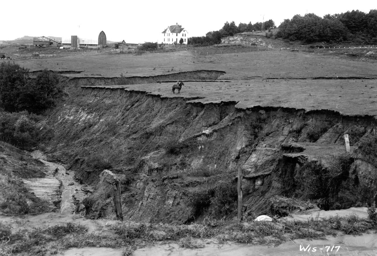
Where once 40-foot deep gullies sliced the landscape, today bears a restored scene as functional as it is artistic.
There is a place in America’s Heartland that still beats a wild, pre-Ice Age pulse all its own. A wooly land with a deep, plush greenness that extends from coulee to ridge and back down and on and on. Water runs like veins, dissecting the soft earth and porous stone with its daily gentle flow; or in times of plenty, a force capable of unfixing century-old homes from their stone foundations, displacing farm implements and fertile soils downriver by miles.

The earth here is dark, productive and holds its shape when tightly bound between palm and knuckles—something my father used to do to impart in me the knowledge of a rich, fertile soil. Stewardship is part of the culture of morality in Wisconsin’s Driftless, and the people are as rooted to the land as the big oaks that stand tall and proud, the final remnants of this former oak savannah.
More than two centuries ago, the People of the Big Voice hunted, gathered and farmed these native riches with a knowledge and respect for the land’s ecological limits. The woodlands were thick with old, robust growth; the prairies diverse and the waters clean. These early peoples, the Ho Chunk Sovereign Nation, also known by their French-given name, Winnebago, were coerced and driven out of Wisconsin in the 1800s when the federal government and westward seeking settlers were lured to the area’s plentiful lead deposits and fertile farmlands. So began the taming of the Driftless.
A distinct ethno- and geographic region in the upper Midwest, the Driftless encompasses a sizable area covering southeastern Minnesota, southwestern Wisconsin, northeastern Iowa and a small portion of northwestern Illinois. It is known geologically as the Paleozoic Plateau. The region has been coined “the Driftless” due to a lack of glacial drift—the silt, clay and rocky material left behind when glaciers retreat. The glaciers of the most recent ice age neglected the region, resulting in an ancient landscape of deeply dissected river valleys (called coulees by the French explorers), steep and rocky canyons, and silt deposits underlain by highly-permeable and fractured Karst limestone geology.
The Driftless is a landscape that, if left to its own doing, would shake off its master’s constraints and return to its misfit ways in a matter of decades. Today, however, it remains a landscape tamed. Tamed as a result of progress and nonconforming land use practices that have caused the near destruction of the native ecosystems. Yet in the taming there is a rare kind of beauty, and the will to tame the ancient can be quite remarkable—as well as profoundly unsettling.
A History of Fervor and Mis-use
The Coon Creek Watershed in southwest Wisconsin is typical of the Driftless: ancient, unglaciated bedrock shaped by water erosion and blanketed with layers of wind-blown silt from areas west of the Mississippi. Over time, this millennia-long activity produced some of the most fertile soil in the world—soil that is exceptionally vulnerable to erosion.
“It took only 70 years, from the time of the first infusion of white settlers to the early 1930s, for traditional farming methods to reduce the land around Coon Creek from pristine to the brink of agricultural uselessness” (Anderson, 2002).
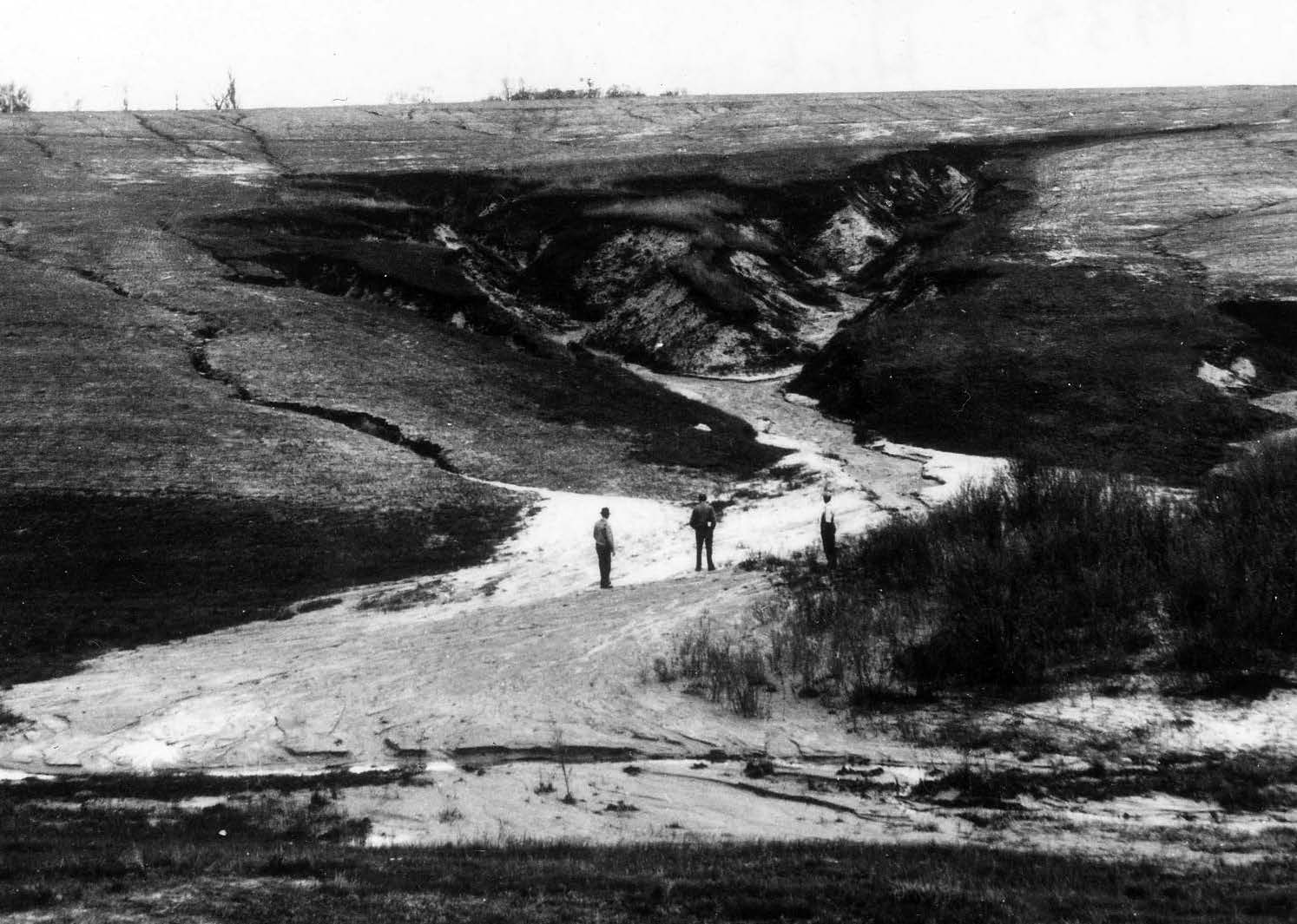
It’s hard to believe when looking at the place now, but just prior to the turn of the century, nearly every ridge to valley floor was cleared and cultivated. The ecological limits of this once wild place were near exhausted, capturing the nation’s attention at a time when the Dust Bowl was wreaking havoc on the prairie states. USDA soil surveyor Hugh Hammond Bennett “campaigned with conviction that soil erosion was among the most urgent of world problems in the 1920s” and recognized the Driftless area of Wisconsin as having “some of the most severely suffering agricultural lands in the nation” (Anderson, 2002).
On the scene and in the press was Wisconsin’s famed naturalist, Aldo Leopold, who wrote Coon Valley “is one of the thousand farm communities which, through the abuse of its originally rich soil, has not only filled the national dinner pail, but has created the Mississippi flood problem, the navigation problem, the overproduction problem, and the problem of its own future continuity” (Leopold, 1935).
The farmers fled as the dust blew, as the rivers choked on sediment, as flash floods yielded gullies 40-plus feet deep and carried the fertile earth downstream, down the Mississippi to the soon-to-be-sediment-heavy Gulf of Mexico.
Birth of a Conservation Movement
Through Bennett’s work, one of ten federalstate Agricultural Research Stations was established in La Crosse, Wis., in 1929. In 1933, Bennett became the first employee of the Roosevelt-era, New Deal-funded Soil Erosion Service (SES), which was later named the Soil Conservation Service (SCS). With Bennett as chief, commanding a skilled team of researchers and technicians, the 92,000 acre Coon Creek Watershed became the chosen site for an innovative conservation demonstration project, becoming the first watershed conservation project in the nation.
In 1934, more than 200 young men with the Civilian Conservation Corps (CCC) arrived in Coon Valley. Supervised by the military and directed by SCS technicians, the CCC implemented conservation measures on hundreds of farms and more than 40,000 acres.
In addition to technical assistance and labor, farmers who were first to sign up received a financial incentive of $.50 per acre, a significant incentive in the early 1930s when land in Vernon County could be purchased for $2 an acre (Anderson, 2002). Conservation measures implemented in the Coon Creek Watershed took into account the whole farm, with the understanding that each element of the SCS plan, when implemented, would increase farm viability and restore soil and water quality while building critical wildlife habitat.
Aldo Leopold played a pivotal role in the initiative’s success, both as a supporter in the media and an on-the-ground technical resource. Leopold believed the SCS conservation plan would offer every farmer in the watershed “a re-organized system of land use, in which not only soil conservation and agriculture, but also forestry, game, fish, fur, floodcontrol, scenery, songbirds, or any other pertinent interests were to be duly integrated. It will probably take another decade before the public appreciates either the novelty of such an attitude by a bureau, or the courage needed to undertake so complex and difficult a task” (Leopold, 1935).
Anatomy of a Contour
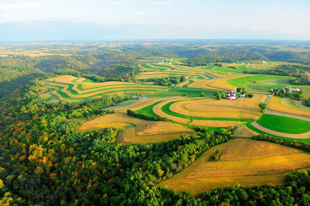
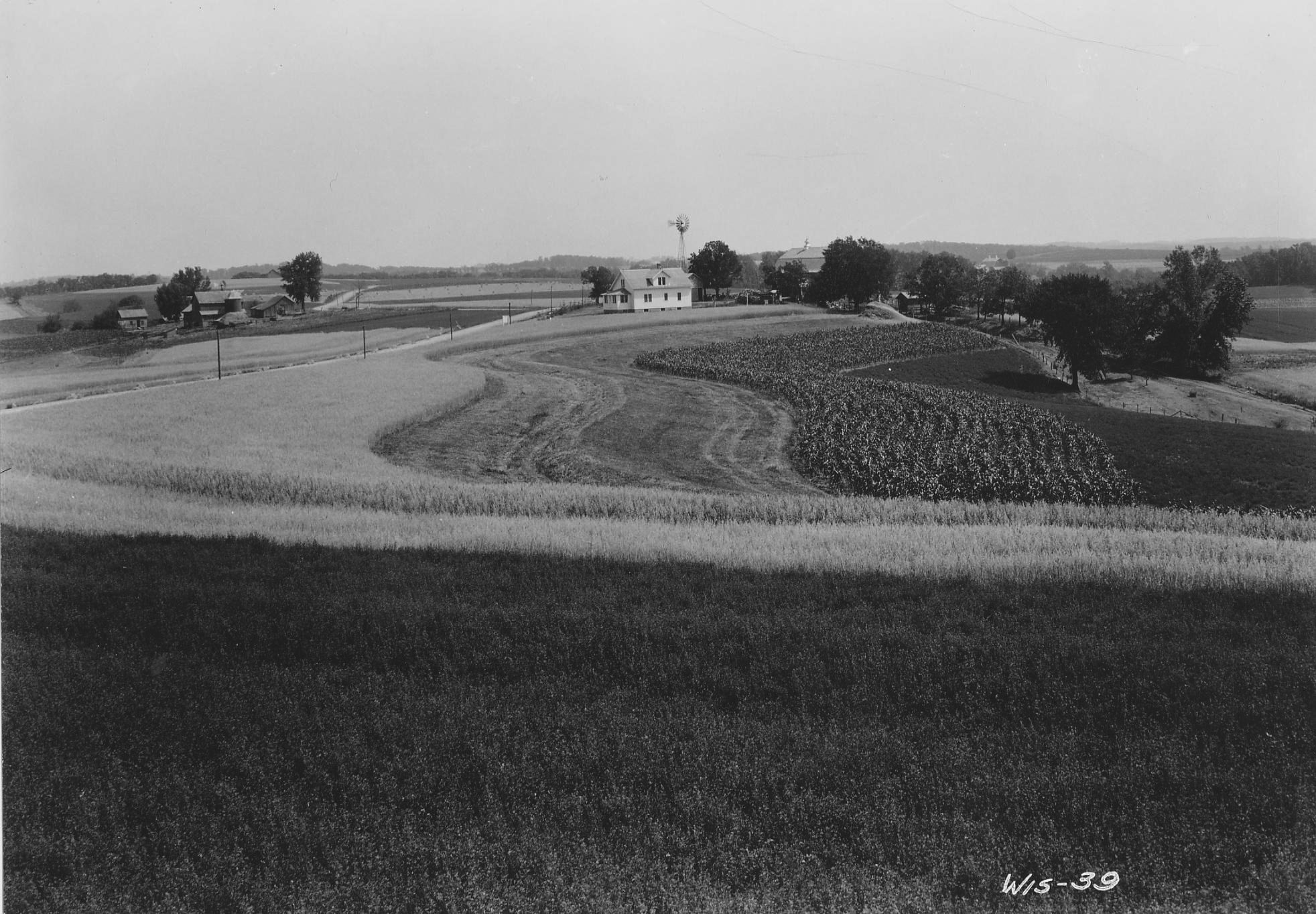
The contour strip, one of the most distinguishing characteristics of the rural Driftless landscape, was a highly successful erosion control measure implemented under the SCS watershed plan. Basic in theory and design, contour strip farming is the practice of planting crops in narrow strips perpendicular to the downward slope, alternating an erosive crop such as corn or soybeans with a nonerosive crop like hay, perennial grasses or legumes.
Non-erosive crops capture and hold water and soil runoff. When a farmer also tills on the contour, each till acts as a small dam, further preventing water—and precious topsoil—from running downhill. These two practices together, non-erosive strips and tilling on the contour, drastically reduce soil erosion caused by water, while also minimizing the loss of fertilizers, herbicides and insecticides.
Vernon County has more acres in contour strips
than any county in the nation.
In the Driftless, where cropland slopes can average 12 to 16 percent grade, contour farming methods protect waterways from excessive sediment, manure and chemical runoff. According to Ben Wojahn, project manager for the Vernon County Land and Water Conservation Department, the use of contour strips can easily result in a 50 percent reduction in soil loss and as much as a 75 percent reduction when grass buffers protect steep cropland waterways and drainages.
Vernon County has more acres in contour strips than any other county in the nation. National Geographic photographed Manske Ridge, a SCS showcase site, for a special December 1995 centerfold image highlighting the beauty and functionality of this conservation practice, drawing global attention to the area.
Contours at Risk
While the practice has proven its economic and environmental effectiveness, the future of contour strip farming remains questionable as the number of family dairy farms in the region decreases. Jeff Hastings, former Vernon County conservationist and current project manager for Trout Unlimited’s Driftless Area Restoration Effort, says the county alone lost an estimated 50 percent of its conventional family dairy farms between 1980 and 2005. The use of contour strips is dependent upon the health of the dairy industry. If we lose the dairy industry, we lose the need for hay and, therefore, the need for a non-erosive crop.
According to the National Agriculture Statistical Service, in 1985 Vernon County had a mere 700 harvested acres of soybeans and the predominant crops were hay (110,000 acres) and corn (60,000 acres). In 2012, the county’s corn acreage remained relatively stable, but soybean acreage saw an incredible 4,000 percent increase, displacing hay, which decreased by 70 percent. This rural land use transition was fueled by a struggling conventional dairy industry and skyrocketing corn and soybean pay prices that encouraged more and more land to be planted with these erosive crops. This also coincided with the increasing practice of no-till farming, which made farming steep hills much easier, resulting in the further removal of contour strips.
One bright spark has been the growth of the organic dairy industry. Family operated organic dairies in the Driftless are typical of small to medium size, and cows graze managed pasture systems of non-erosive, perennial grasses and legumes. According to Wojahn, 75 percent of the contour strips installed in Vernon County in recent years has been on organic dairy farms where farmers value a hay/corn rotation for supplemental feed. Supporting the growing organic family-owned and operated dairy industry will have an enormous impact on the health of the Driftless landscape.

Revisioning
The early watershed conservation measures implemented by SCS (which morphed into the Natural Resources Conservation Service in 1994) are still considered best practices for farms today. Since 1934, more than 95 percent of the Coon Creek Watershed has come under a conservation plan. Over time, soil erosion in the watershed has decreased by 75 percent on sloping cropland, gullies have decreased by 77 percent, and grazed woodlands have decreased by 85 percent (Anderson, 2002). Farm economics improved, and the area’s cold-water stream ecosystems have shown enormous signs of improvement.
But while these statistics show the Coon Creek Watershed’s health has dramatically improved, elsewhere, decades of effective landmark conservation work is disappearing right before our eyes. With fewer and fewer contour strips on the landscape and more and more mono-crop, conventional agriculture methods used, our soil and our water is increasingly vulnerable. As we succumb to rising and falling markets and practices that compromise the integrity of this unique landscape, we are reminded that observation and practice in the name of ecological conservation and restoration is the best and least damaging method of taming a place that reminds us again and again of its native ways.
Millions of dollars are spent every year in the Driftless to maintain a conventional agricultural system that simply doesn’t fit the anatomy of a steeply contoured landscape. Hastings argues that the “Driftless is not suited for corn and soybeans or large livestock operations. Instead, it presents enormous opportunity for managed grazing.” Non-erosive perennial grass and pasture systems—systems not unlike the area’s former native savannah prairies—will over time restore and maintain our fertile soils and healthy cold-water streams and watersheds.
Maybe what we need is a little less taming and a little more native.

Sources:
Anderson, Renae. “History of the Coon Creek Watershed.” USDA Natural Resources Conservation Service. Madison, WI. Wisconsin Academy of Sciences, Arts and Letters. Pp. 42-48. Volume 48, No. 2, Spring 2002.
Leopold, Aldo. “Coon Valley: An Adventure in Cooperative Conservation.” American Forests magazine, 1935. As taken from Renae Anderson’s “History of the Coon Creek Watershed.” USDA Natural Resources Conservation Service. Madison, WI. Wisconsin Academy of Sciences, Arts and Letters. Pp. 43 and 45. Volume 48, No. 2, Spring 2002.
More Stories by This Author

Edible in your mailbox